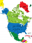
North American Colorful Map
This free colorful map of the North American countries is sure to fulfill your educational needs; whether you need a reference map or a printable for a poster project, this free downloadable map can offer it all.
On this map you will notice the different countries that map up North America. In addition to the color coded countries, major cities are also labeled. This map makes a wonderful reference for any little learner’s geographical needs. Help your child out today by downloading this free North American map!